


|
Key Takeaways: |
|
• You may begin the 125-kilometer Cape to Cape trek from either the Cape Naturaliste Lighthouse or the Cape Leeuwin Lighthouse in Augusta, Western Australia. • Staying hydrated and maintaining a healthy diet are crucial for conserving energy during a trek. • A schedule for a seven-day trek from Cape to Cape is provided in this handbook. • Besides the Cape to Cape Hike, other attractions include Sugarloaf Rock and Wilyabrup Sea Cliffs. • We recommend Jackery Explorer 600 Plus and 300 Plus to charge the essential electronics and devices for your hike, such as your phone, radio, GPS device, and more. |
Cape To Cape Hike Overview
Between the lighthouses of Cape Naturaliste and Cape Leeuwin in the far southwest of Western Australia, the 123 km Cape to Cape Walk Track winds along the Leeuwin-Naturaliste Ridge. The ridge's amazing geology of cliffs, caverns, headlands, and rock formations and constantly shifting displays of plants and wildflowers create a breathtaking coastline and woodland picture.
The towns of Dunsborough, Yallingup, Margaret River and Augusta provide a complete choice of lodging, retail, dining, and entertainment venues. There are sightseeing trips, dive and fishing charters, and four-wheel-drive safaris.
Length: The trail is 123–135 km long
Time to Complete: It usually takes 4–7 days to complete
Difficulty: Suitable for all experience levels, but there are some steep sections and challenging beach walking.
Starting Location:
Cape Naturaliste Lighthouse or
Cape Leeuwin Lighthouse
We recommend starting north at the Cape Naturaliste Lighthouse and finishing south at Cape Leeuwin Lighthouse.
Finishing Location:
Cape Leeuwin Lighthouse, Augusta, Western Australia
Best Time to Hike the Cape to Cape:
Year round. This walk differs significantly from interior trails because it is a beach trek. The Cape to Cape Track ecosystem is mainly Mediterranean, with most of the 1,000 mm of rainfall falling during the milder winter months.
|
Season |
Temperature |
|
Summertime daytime averages (February) |
Maximum 27.1°C Minimum 14.4°C Rain days average 3 days |
|
Wintertime daytime averages (July) |
Maximum 16.4°C Minimum 8.2°C Rain days average 19 days |
Your motivation for hiking this trek may change depending on when you travel it. Here are a few things to think about:
Avoid the school vacations, Christmas, and Easter if you want some alone time.
If whale watching is your goal, consider trekking from June to July.
Look for wildflowers between September and mid-October.
Avoid November through March if you can't stand the heat, as these months can have very high temperatures relative to seasonal norms.
July is the wettest month of the year, so if you don't enjoy the rain, avoid May through September.
How to Prepare for Your Cape To Cape Hike?
To guarantee a safe and happy hiking experience, preparing well before setting out on your hiking journey is essential. Here is a thorough how-to to get you going for Cape to Cape hike:
Essential Pre-Hike Preparations
To set up camp or begin your trip with plenty of daylight, try to reach your location before dusk. Ensure your phone battery is ultimately charged before you go on your journey. Bring a friend or two if you can. They can offer companionship, guidance with navigation, and assistance in the event of an injury.
Hiking Clothing
Invest in quality hiking boots and socks that wick away moisture to avoid blisters. Adapt your gear to the terrain, the time of day, and the weather. Wear a wide-brimmed hat, sunglasses, and sunscreen with an SPF of 30 or higher. Use sunscreen again every two hours.
Wear layers of clothing to make weather adjustments easier. Carry at least one additional layer of clothes and cover up with moisture-wicking layers over cotton.
Planning and Navigation
Plan and thoroughly study your trip. Look out for possible wildlife, toxic plants, and hiking advisories. Use route maps, guidebooks, or GPS files.
Find more about local weather trends and ask rangers about park conditions. Even on day climbs budget for an overnight stay to account for unforeseen circumstances.
Remember to leave no trace by being aware of local laws, regulations, and unique issues. Use a map and compass to prevent leaving markings, and repackage food to save waste.
Including these preparations in your hiking routine will make it much safer and more enjoyable. Organising, packing appropriately, and being ready for any situation create the circumstances for a successful outdoor activity.
Essential Gear for Hiking Safety
The appropriate equipment on the trail is crucial for your safety and readiness. Here is a thorough list of all the necessary equipment for safe hiking, broken down into categories to make packing easier.
Pack the less used, lighter gear on the bottom of the pack, which covers items such as the sleeping system (mat, mat, and liner for sleeping bag). Pack heavy gear close to the centre of your back. This covers the majority of your meals as well as your bladder of water. Pack the frequently used gear on top. It takes care of most of your meals and your water bladder.
|
Cape to Cape Hiking Essentials |
||
|
Hiking Clothing |
||
|
Quick-Drying Underwear |
Quick-Drying Shorts/Pants |
Synthetic Wool T-shirt |
|
Waterproof Rain Jacket |
Outer Layer |
Thermal Socks |
|
Camping Gear |
||
|
Backpack |
Tent |
Sleeping Bag |
|
Liner |
Inflatable Pillow |
|
|
Navigation & Emergency |
||
|
Whistle |
Smart Phone |
Map |
|
Compass |
GPS / PBL |
First Aid Kit |
|
Extra Supplies |
||
|
Water Bottle |
Water Purification |
Snacks |
|
Sun Protection |
Wet Wipes |
Jackery Portable Power Station |
Always have a paper copy of your map and compass if your electronic gadgets die. GPS units and navigation applications are helpful for additional navigation, but remember that technology isn't always dependable—a portable, trustworthy satellite communication device for emergencies.
Carry a satellite or cell phone with a whistle and mirror in an emergency. Bring supplies appropriate for the particular walk, such as bandages, sterile wipes, analgesics, and a space blanket. For preparation, think about enrolling in a first aid course.
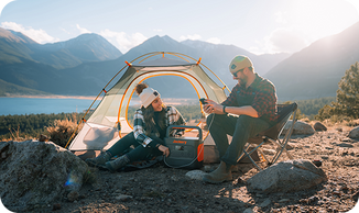
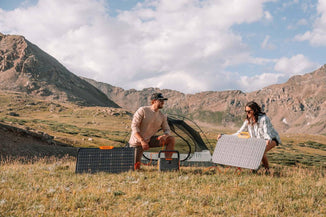
Jackery Portable Power Stations can make hiking more fun and powerful since electricity is vital, especially for overnight hiking.
Bring a small power station like the Jackery Explorer 300 Plus or Explorer 600 Plus to charge your electronics (GPS devices, communication tools, and personal electronics) on your hiking trip. They are only the size of a book or a ball, so you can easily take them everywhere.
7-Day Cape to Cape Hike Itinerary
In Western Australia's Margaret River Region, the 125-kilometer Cape to Cape route stretches along the coast from Cape Naturaliste to Cape Leeuwin. This 7-day Cape to Cape hike plan will help you have a fantastic journey.

Day 1: Cape Naturaliste to Yallingup | 14km
The trip from Cape Naturaliste to Yallingup takes hikers across around 13 km of varied coastal terrain in the Margaret River area of Western Australia. The walk begins at Cape Naturaliste and meanders over limestone cliffs, providing expansive vistas of the turquoise seas of the Indian Ocean slamming against the untamed coastline.
Hikers encounter remote beaches along the route, such as Wyadup Rocks and Boneyards Beach, renowned for its immaculate sands and peaceful tidal pools perfect for a cool dip. The trail winds through wildflower-covered coastal heathlands that serve as habitats for local bird species and offer sporadic views of wallabies and kangaroos. Near Yallingup, well-known for its surf breaks and breathtaking coastal views, the journey comes to a satisfying finish for both nature lovers and adventurers.
Day 2: Yallingup to Moses Rock | 20km
The walk heads south along the coast in Yallingup Beach, well-known for its world-class surf breaks and pristine seas. Along the journey, hikers may see sandy coves, rocky cliffs, and vast vistas of the Indian Ocean. One of the highlights is the well-known Canal Rocks, where waves from the ocean smash through slender channels in the granite rocks to create a breathtaking natural display.
As the walk continues south, it passes through natural bushland and coastal heath, providing views of local animals such as kangaroos, emus, and several bird species. This portion ends at Moses Rock Beach, a secluded, unspoilt beach renowned for its outstanding surfing conditions and natural beauty.
Day 3: Moses Rock to Gracetown | 16km
The walk runs south from Moses Rock Beach via natural vegetation and coastal dunes. The beach is well-known for its isolation and fine beaches, offering a tranquil environment for unwinding and taking in the sound of breaking waves.
As hikers continue along the route, they are treated to expansive vistas of the Southern Ocean framed by rocky outcrops and craggy limestone cliffs. The path meanders through coastal heathlands covered in springtime wildflowers, which give the surroundings vivid pops of colour.
One of the route's most recognised features is the famous Wilyabrup Cliffs, towering limestone structures that provide breathtaking views of the ocean below. During the whale migration season, which runs from September to December, these cliffs are a popular place to see these magnificent animals breaking the ocean's surface.
Day 4: Gracetown To Prevelly| 21KM
The walk begins with views of Cowaramup Bay and ends in Gracetown, a little seaside village between rocky cliffs and immaculate beaches. The bay is well-known for its azure seas and white sand beaches, which provide opportunities for a revitalising swim or just lounging around and taking in the coastal atmosphere.
One of the route's highlights is the famous Cape Mentelle, where the path gives broad views of the coastline and the Cape Mentelle Vineyards. The unspoilt splendour of the Cape offers the ideal setting for both nature lovers and photographers.
As it continues south, the route finally comes to Prevelly, a seaside community known for its world-class surf breaks and gorgeous beaches. Hikers may unwind on Gnarabup Beach's sandy sands, visit the town's cafés and shops, or take in the laid-back vibe unique to this area of the Margaret River region.
Day 5: Prevelly to Boranup Forest | 21km
The track heads south along the coastline for the first part of its course, beginning in Prevelly, a seaside community renowned for its gorgeous beaches and surf breaks. The trail is dotted with limestone cliffs and sandy beaches, offering hikers magnificent vistas of the Indian Ocean. The gorgeous Prevelly Beach is a great place to begin, with the sound of breaking waves and a sea wind creating the perfect atmosphere for an exciting hike.
As it heads inland, the route enters the magnificent Boranup Karri Forest. This forest is distinguished by its towering karri trees, which provide a tranquil canopy above. The woodland contrasts with the coastal scenery seen earlier in the trek because of its famed natural beauty and biodiversity. Strolling about among these old trees—some towering over 60 meters—offers peace and breathtaking beauty.
Day 6: Boranup Forest to Cosy Corner | 21km
The route begins in Boranup woodland, which is well-known for its towering karri trees. It first meanders across the peaceful woodland floor. Among the tallest hardwoods globally, the karri trees provide a tranquil environment due to their majestic height and the way sunlight dapples over their canopy.
Eventually, the walk comes to Cosy Corner, a charming beach between limestone cliffs. Cosy Corner is a great place to unwind and rest after trekking because of its pure white dunes, crystal-clear blue waters, and serene atmosphere.
Day 7: Cosy Corner to Cape Leeuwin | 22km
You'll pass through native bush and coastal heathlands, home to various animals, including emus, kangaroos, and many bird species. The trail provides sweeping views of the Southern Ocean, where the untamed deep blue water merges with the rocky shoreline. The famous Cape Leeuwin Lighthouse guards the turbulent waters, offering breathtaking views of the rocky shoreline and acting as a light for seafarers.
Jackery Portable Power Stations for Hiking
With 123 kilometres of magnificent coastline, limestone cliffs, and tranquil woodlands, Western Australia's Cape to Cape Track is a fantastic experience. Having dependable energy on hand can make all the difference, whether hiking the entire distance or just a portion.

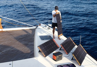
Jackery Portable Power Stations are ideal for multi-day hikers since they offer clean energy for recharging phones, GPS units, or cameras, allowing you to enjoy this breathtaking journey fully. You may enjoy the trip without sacrificing your connection to the necessities by pairing them with Jackery Solar Panels for on-the-go charging. Your Cape to Cape trip will be conveniently and sustainably fuelled by Jackery.
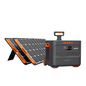
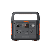
Jackery Explorer 600 Plus
Power your adventures sustainably with the Jackery Explorer 600 Plus Portable Power Station. This compact and portable unit weighs just 7.3kg yet packs a punch with an 800W output and 632Wh capacity. It's an ideal choice for eco-conscious users, offering whisper-quiet operation (≤22dB) and emission-free performance, perfect for hiking.
Charge up fast with versatile options: a full recharge takes just 1.6 hours via wall outlet or 4.3 hours with dual SolarSaga 100W solar panels. Activate the Emergency Super Charging Mode via the Jackery app to achieve a full charge in just 1 hour, ensuring you're always prepared for unexpected power needs.
With UPS functionality and a long-lasting LFP battery (4000 cycles), the Explorer 600 Plus prioritises safety and reliability. Its shockproof and fireproof design and high-level safety certifications make it the ultimate eco-friendly power solution for home and outdoor use.

|
Jackery Explorer 600 Plus Working Hours |
|
|
GPS Device (60W) |
9H |
|
Radio (50W) |
10H |
|
Camera (150W) |
3.6H |
|
Headlamp (20W) |
27H |
|
Drone (90W) |
6H |
Review from Our User:
I bought the Jackery Explorer 600 plus to serve as the power source for my electric guitar busking. Last Friday, I had my first busking session, and the unit performed excellently. It efficiently powers my large speaker, mixer, and guitar effects unit, using only 11% in an hour and a half while running all that equipment. This product comes highly recommended.
Jackery Explorer 300 Plus
The Jackery Explorer 300 Plus Portable Power Station redefines portability and performance. Weighing just 3.75kg, this ultra-lightweight power station is designed for maximum convenience, allowing you to carry it in your backpack for hiking quickly. Its compact size doesn't compromise its power, offering a 288Wh capacity and 300W output to keep your essential devices running smoothly.
Equipped with cutting-edge features, the 300 Plus ensures versatility for various scenarios. Its dual USB-C ports with up to 100W output support fast and simultaneous charging, making it ideal for laptops, tablets, and smartphones. With four charging options—solar, AC wall outlet, car port, and USB-C—you'll always have a way to recharge, whether at home, on the road, or in the wilderness. Plus, it's whisper-quiet and completely emission-free, ensuring it is both eco-friendly and convenient.
The Explorer 300 Plus is built to last, featuring an LFP battery with an impressive 10-year lifespan and over 3,000 cycles to 80% capacity. Safety is at the core of its design, with advanced ChargeShield Technology offering 52 layers of protection against overvoltage, short circuits, and more. Whether camping, travelling or preparing for emergencies, this portable power station provides reliable and safe energy solutions that adapt to your lifestyle.

|
Jackery Explorer 300 Plus Working Hours |
|
|
GPS Device (60W) |
4H |
|
Radio (50W) |
5H |
|
Camera (150W) |
1.6H |
|
Headlamp (20W) |
12.2H |
|
Drone (90W) |
2.7H |
Review from Our User:
I own multiple Jackery Power Stations. I purchased this smaller unit while remodelling our home, and it's convenient to have outlets available since our A/C is temporarily disconnected.
Safety Tips for The Cape to Cape Hike
The following are the safe tips for hiking the cape to cape.
Adhere to any posted signage and stay on the approved trail.
Be cautious while approaching cliff edges and take note of uneven ground.
Before your hike, check the weather forecast and make necessary preparations.
There might not be many water sources along the path, so bring extra water.
Tell someone where you're going hiking, how long it will take, and when you intend to return.
Hydration: The Lifeline of Hiking
Carry and drink at least one litre of water every two hours of hiking. The climb's difficulty level, the outside climate, and personal health issues can all influence how much water is needed. Try to drink 0.5–1 litre of water per hour, and modify as necessary.
Dehydration can be identified by its symptoms, which include an elevated heart rate, decreased endurance, and poor focus. To do a quick hydration assessment, keep a regular eye on the colour of your urine.
Always carry enough water, and think about packing a hydration backpack for convenient access. In situations when you may sweat a lot, replace lost fluids to keep your body temperature stable and avoid becoming too hot.
Wildlife Awareness and Safety
Your safety and that of the animals is of utmost importance when trekking in regions where wildlife is present. Here are some crucial pointers to guarantee a secure meeting:
Make noise to get an animal's attention, particularly in crowded situations with poor vision. By doing this, you may avoid surprising them, which frequently results in assaults by animals.
Use bear-proof containers or higher storage options to protect your food and fragrant goods from wildlife. This will help keep animals away from your campground.
Be mindful of your surroundings at all times. When you encounter animals, keep your distance and never try to pet or feed them. These behaviours may elicit hostility and result in unpredictable conduct.

Highlights in Cape to Cape Hike
There are several sections of the Cape to Cape track that are considered to be the best.
Cape Naturaliste
The comparatively protected waters of Geographe Bay are divided from the southern Indian Ocean by Naturaliste, the northernmost point of the Leeuwin-Naturaliste Ridge.
The 20-meter-tall lighthouse is located on a 100-meter hill with a view of Geographe Bay. In 1903, limestone from a quarry 1.5 km distant was hauled by bullock waggon and used in its construction. The three original quarters for keepers remain intact.
A portion of the Cape to Cape Track is reachable between Sugarloaf Rock and the Cape Naturaliste Lighthouse. This is a top-notch path offering a fantastic experience. It has over a km of wood boardwalk, benches all along the walk, and parking lots at Sugarloaf Rock or the northern end near the lighthouse. This trail is rated 1:12 and wheelchair-accessible.
Wilyabrup Sea Cliffs
The initial impression of the Wilyabrup Cliffs is one you will never forget. Standing forty metres tall, they shine crimson against the whiteness of the rushing water. Amazingly, not many individuals are aware of their existence.
Because of the cliffs' breathtaking natural beauty, it's understandable why Jeremy Clarkson refused to leave, why Natalie Imbruglia chose this location for her one day off in the South West, and why this is the ideal location for a proposal.
Sugarloaf Rock
A massive granite outcrop called Sugarloaf Rock rises from the Indian Ocean near the mainland. The rock is within a protected nature reserve in the Leeuwin-Naturaliste National Park, close to Dunsborough. It is positioned off Cape Naturaliste. As you get closer to this massive, sea-sculptured rock, you will quickly understand why Sugarloaf Rock is one of the most photographed coastal formations in the area.
This amazing landscape is best observed from the elevated overlook. A short channel of wild water divides the rock from the shore, and hazardous seas frequently pummel its ocean side.
Cape To Cape Hike FAQs
The following are the frequently asked questions about the Cape to Cape hike.
1. Is the Cape to Cape walk hard?
The diversity and character of the terrain make walking the Cape to Cape Track a challenging experience at times. It needs to be planned. Experiences range from long hikes on smooth sand beaches to quick, sharp climbs over loose rock.
2. Are there toilets on the Cape to Cape?
Four simple campsites lack shelter but have tables, restrooms, and little water tanks. There are private caravan sites in Yallingup, Gracetown (3 km off the Track), Prevelly Park, and Hamelin Bay, as well as National Park camps on the Track (Contos has water) and Point Road (no water).
3. Can you ride the Cape to Cape Track?
Parks and Wildlife Services oversees the Cape to Cape Track, which is nearly entirely located inside the Leeuwin-Naturaliste National Park (DPaW). Dogs and wheeled vehicles are not allowed on the track; it is only for pedestrian use.
Final Thoughts
Are you prepared to go out on a trip you won't soon forget? The breathtaking coastline of Western Australia's Cape to Cape Track is beckoning. This path runs 123 km across 123 miles of spectacular landscape from Cape Naturaliste to Cape Leeuwin and is complete with historical sites, natural wonders, and life-changing adventures. The Cape to Cape hike offers something for everyone, whether looking for adventure or peace outdoors, walking at your leisure or with a guide.


